Leveraging Point Clouds for Vegetation Encroachment Assessment: A Drone-Enabled Approach
This article from Blue Marble Geographics highlights how advanced point cloud analysis can support vegetation fire risk assessment. Blue Marble is known for its geospatial software, including Global Mapper and Global Mapper Pro, which provide powerful tools for working with LiDAR, photogrammetry, and other complex datasets. These solutions enable users across industries—from utilities to forestry—to transform raw data into actionable intelligence.
Vegetation encroachment around critical infrastructure—such as power lines, substations, roads, and buildings—is a well-known hazard that threatens safety and operations. Traditional field surveys are labor intensive and limited in spatial coverage. By contrast, drone mapping and point cloud analysis offer scalable, precise methods to detect and manage encroachment before it becomes critical.
Why Vegetation Monitoring Matters
Unchecked tree growth and overgrown shrubs near utilities or built assets pose multiple risks: they can fuel the ignition and spread of wildfires, cause physical contact or proximity violations with conductors or structures, and complicate maintenance, inspection, and reliability efforts.
Given these stakes, environmental and utility operators seek remote sensing methods that combine accuracy, repeatability, and operational efficiency.
Drones equipped with LiDAR or photogrammetric sensors can collect dense point clouds over large areas, providing the raw data needed to quantify clearance distances, vertical profiles, and spatial trends. But the real value emerges when you can classify, filter, and analyze those point clouds and export actionable intelligence to field teams.
Point Cloud Workflows for Encroachment Detection
Here’s a step-by-step breakdown of a typical workflow for detecting vegetation encroachment using point cloud data:
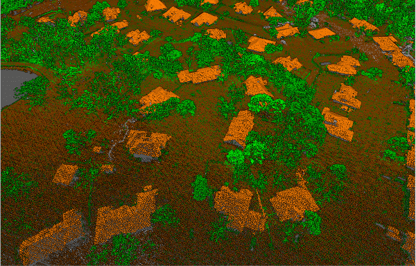
1. Classify the Point Cloud
Separate terrain, vegetation, and man-made features. Automated classifiers help accelerate this step, with manual review ensuring accuracy in complex environments.
Classified building, vegetation, and ground points are visually distinguished by color.
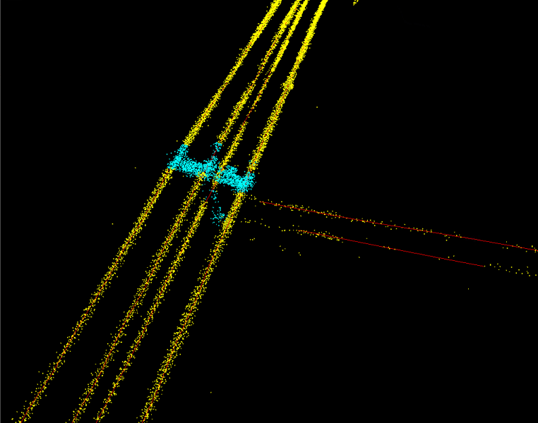
2. Identify Asset Features
Isolate at-risk features such as powerlines or buildings. Converting these into vector formats can improve proximity analysis.
Points representing powerline features (yellow) were extracted into 3D vector line features (red).
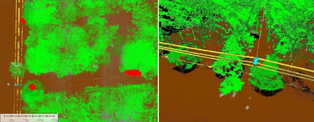
3. Select Encroaching Vegetation
Apply spatial filters or buffer operations to flag vegetation points within clearance zones. These thresholds are often dictated by regulatory standards.
Vegetation points within 2m of the power lines have been automatically detected and highlighted, as shown in 2D and 3D views.
4. Generate Field-Ready Outputs
Deliverables such as bounding boxes or vector layers can be exported to mobile devices, enabling field crews to validate and update findings in real time.
Integrating Drones and Field Operations
By combining drone surveys with point cloud analytics, flagged encroachment zones can be shared directly with maintenance teams. These teams can then validate, annotate, and mark clearance work in the field, creating a continuous loop of feedback. Regular drone surveys also allow for trend analysis of vegetation growth, giving operators a proactive tool to stay ahead of risks.
Practical Considerations
- Point Density: High-density data may be needed to detect smaller branches or narrow clearances.
- Classification Accuracy: Mixed land cover and dense canopies can complicate results.
- Threshold Balance: Too strict may create false positives; too lenient may miss hazards.
- Data Volume: Managing and storing large point clouds requires efficient workflows.
- Field Transfer: Ensuring version control and mobile compatibility avoids mismatches in the field.
The Role of Software in the Workflow
Software solutions like Blue Marble Geographics’ Global Mapper provide an environment for classification, filtering, and mobile deployment of point cloud data. With tools for editing and exporting data directly to Global Mapper Mobile, the platform helps bridge the gap between office-based analysis and field execution, streamlining vegetation management strategies.
Drone-enabled point cloud analysis is shaping how organizations monitor and mitigate vegetation encroachment near critical infrastructure. By creating efficient workflows that connect data capture, analysis, and field operations, operators can move from reactive to proactive vegetation fire risk management.


