
BRINC iOS App Delivers Live Drone Footage to First Responders
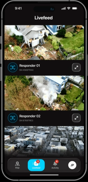

The LiveOps iOS application enables emergency personnel, including officers and firefighters, to stream aerial video directly to their mobile devices. This capability allows incident commanders to evaluate hazards before teams enter dangerous zones.
BRINC has released a new iOS application that grants first responders immediate access to live drone video and operational data on iPhones and iPads. Authorized users can view the perspective of agency drones even when they are operating away from a central command center.
Launched on November 17, the application expands the functionality of BRINC’s existing LiveOps platform to mobile devices. It is built to support officers, firefighters, and other emergency staff in making informed decisions during the pre-response and active response phases.
This update addresses a critical need as Drone as First Responder (DFR) initiatives grow. Although drones often arrive at emergency scenes before ground units, the value of their data depends on its timely delivery to the decision-makers on the ground.
Bringing Aerial Intelligence Directly to First Responders
DFR programs allow public safety agencies to dispatch drones in response to emergency calls, frequently preceding the arrival of officers or firefighters. These aircraft provide an initial visual assessment of the scene, aiding responders in identifying hazards, evaluating conditions, and formulating their approach.
Previously, users accessed BRINC’s LiveOps platform via a web browser. The new dedicated mobile application simplifies this process, making critical information more accessible while responders are actively in the field.
For example, an officer responding to a potentially volatile call can review live aerial video before approaching a structure. The footage may reveal the location of suspects, nearby vehicles, or other environmental factors that could impact the response strategy.
Similarly, firefighters approaching a structure fire can use aerial video to evaluate the building and its surroundings before committing personnel. An incident commander can simultaneously monitor multiple drone feeds to coordinate teams across a large emergency scene.
These features help responders avoid entering high-risk situations without a clear understanding of the potential dangers. They also facilitate more measured responses when immediate intervention is not required.
"DFR is becoming a source of real-time intelligence for entire public safety organizations, not just the people flying drones," said Blake Resnick, Founder & CEO of BRINC. "With the LiveOps iOS app, we’re putting that intelligence directly into the hands of first responders. Whether they’re en route to a call, establishing incident command, or coordinating resources in the field, they can see what’s happening from above right from their phone."
Connecting Drone Operations Across an Agency
The LiveOps mobile app enables authorized users to monitor multiple drones through adjustable live video feeds. Personnel can track agency-wide drone activity and real-time airspace conditions without needing to return to an operations center.
This app complements BRINC’s broader LiveOps platform, which consolidates drone operations, video streaming, fleet management, and evidence storage into a single ecosystem.
LiveOps also integrates with computer-aided dispatch (CAD), evidence management systems, and other public safety infrastructure. These connections allow agencies to embed drone information directly into existing emergency response workflows. BRINC’s CAD integration enables dispatch systems to send calls for service and their specific locations directly to LiveOps. Drone operators can then launch aircraft to those coordinates without manually entering the data.
The platform also provides secure storage and management for recorded visual and thermal video, maps, and flight logs within a CJIS-compliant environment.
Administrators can manage access permissions based on user roles and teams. BRINC states that its security framework includes AES-256 encryption, two-factor authentication, and data hosting exclusively within the United States.
Why Mobile Access Matters for First Responder Safety
The growth of DFR programs has transformed how public safety agencies utilize drones. Instead of waiting for a specialized drone team to arrive before deploying an aircraft, agencies can now send drones directly to emergency calls.
BRINC’s Responder drone and automated charging stations facilitate this approach. The company has also broadened access to DFR technology through initiatives like its partnership with the National League of Cities, announced in March 2026.
As these programs expand, a primary challenge is ensuring that drone data reaches the individuals who need it most. Providing these feeds on mobile devices reduces the reliance on responders receiving information secondhand from drone operators or dispatchers.
The app does not replace the judgment of trained responders, nor does aerial video reveal every possible hazard. However, direct access to current visual information helps personnel make decisions with a deeper understanding of the situation.
The broader significance lies in the fact that DFR technology is evolving into a resource for entire public safety organizations, rather than remaining a tool used primarily by drone pilots and specialized teams.
The BRINC LiveOps iOS app is now available via the Apple App Store. Existing BRINC customers can access the app using their current accounts.