
From Power Lines to Mine Shafts: Lidar Expands the Reach of Drone Mapping
Ouster partnerships with GeoCue and Flyability show how next-generation lidar is supporting applications above infrastructure and deep inside confined spaces
Two recent partnerships from lidar developer Ouster highlight the expanding role of lidar in commercial drone operations. The applications range from surveying utility infrastructure from the air to mapping confined industrial spaces where GPS and conventional cameras may not work.
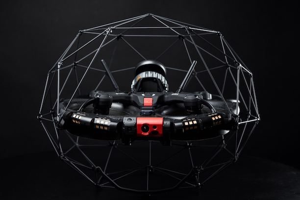
Ouster and Flyability announced this week that they are building on a five-year technology partnership centered on Flyability’s Elios 3. The collision-tolerant drone is designed for inspection and mapping inside mine shafts, wastewater tunnels, tanks, industrial vessels and other difficult or hazardous spaces.
The announcement follows a partnership unveiled last week between Ouster and GeoCue. GeoCue plans to integrate Ouster’s Rev8 OS1 Max digital lidar into its TrueView drone mapping systems for utility and infrastructure surveying.
Together, the two applications illustrate how improvements in lidar range, resolution and data capture could support increasingly diverse drone operations.
Mapping Where GPS and Cameras Fall Short
Flyability’s Elios 3 combines a protected, collision-tolerant airframe with Ouster’s compact OS0 lidar. Lidar data feeds the drone’s SLAM and mapping systems, supporting real-time localization, flight stability and collision avoidance.
Those capabilities become especially important inside structures where GPS is unavailable. Darkness, airborne dust and surfaces without distinctive visual features can also limit camera-based navigation.
The system allows operators to capture measurable 3D representations of assets while conducting inspections, reducing the need for workers to enter potentially hazardous areas.
“Flyability has demonstrated how digital lidar can create real operational value when it is taken into environments that conventional surveying systems cannot easily reach,” said Ouster CEO Angus Pacala. “Our collaboration brings together rugged, high-density 3D sensing and a unique aerial inspection platform, helping industrial teams understand critical assets while reducing the need for people to enter hazardous spaces.”
Flyability is now evaluating Ouster’s newer Rev8 lidar technology for future inspection workflows. Ouster says the Rev8 generation increases range and resolution while adding native color to the 3D data.
“Our collaboration with Ouster began with a shared ambition: to capture reliable 3D data in places where people should not have to go,” said Adrien Briod, CTO at Flyability. “Ouster’s lidar has become a critical part of the Elios 3 mapping platform. Bringing our teams together at INTERGEO gives us the opportunity to show surveying professionals how aerial access and high-performance lidar are already changing the way complex industrial environments are documented and understood.”
The companies will demonstrate the technology at INTERGEO 2026, taking place September 15-17 in Munich, Germany.
Taking the Same Technology to Large-Scale Mapping
The GeoCue partnership puts the latest Ouster technology into a very different operating environment.
GeoCue is expanding its TrueView product line with options using Ouster’s 256-channel Rev8 OS1 Max lidar. The companies are targeting utility and infrastructure applications, including power line mapping and long-corridor surveys.
Ouster says the sensor can detect targets with 10% reflectivity at distances up to 200 meters. A smaller spot size and tighter beam are designed to help resolve thin features such as power lines and structural edges. The system also provides native color lidar data, combining color and 3D information at the sensor level.
GeoCue selected the sensor after joint flight testing and firmware tuning in Huntsville, Alabama.
“We are moving America’s drone surveying onto American sensing by pairing our TrueView payloads with Ouster’s Rev8 OS1 Max,” said Frank Darmayan, CEO of GeoCue. “This transition allows us to offer our customers a compliant, high-performance solution that delivers the survey-grade data they depend on for critical infrastructure monitoring and large-scale mapping projects.”
The Rev8 OS1 Max is also compliant with Build America, Buy America Act requirements, an important consideration for some federally funded infrastructure projects.
Lidar Expands Across Drone Applications
The two partnerships demonstrate very different uses of the same underlying sensing technology.
With GeoCue, lidar is designed to capture precise data across large infrastructure assets from above. With Flyability, lidar helps a drone navigate and map spaces that may be inaccessible from outside and unsafe for people to enter.
In both cases, the value extends beyond creating a point cloud. Lidar increasingly supports navigation, localization and autonomous operation while also generating the 3D data required for inspection and mapping.
As sensors gain range, resolution and richer data, that overlap between perception and data collection could become increasingly important. The drone is no longer simply carrying a mapping sensor. In applications such as the Elios 3, the sensor that creates the map can also help the aircraft understand where it is and operate where other navigation technologies fall short.